

The Ganges and the Rivers that Built Civilisations
Reference library · 1099 words

The Ganga, known in English as the Ganges, begins at Gaumukh, the snout of the Gangotri glacier in the Uttarakhand Himalaya, at an altitude of around four thousand metres. The stream that emerges there is called the Bhagirathi; it takes the name Ganga only at Devprayag, where it joins the Alaknanda flowing down from the higher peaks. From there it runs some two and a half thousand kilometres east and south east across the plain to the Bay of Bengal. Its basin covers around a million square kilometres across India, Nepal, Bangladesh and a slice of Tibet, and supports several hundred million people, which makes it the most densely populated large river basin in the world. Where it meets the Brahmaputra and the Meghna it forms the largest delta on earth, whose seaward fringe is the mangrove forest of the Sundarbans.
The physical explanation for why so many people live there is straightforward and worth stating. Himalayan rivers carry immense loads of sediment ground from young, rapidly rising mountains. As they leave the hills and slow across the plain they drop that sediment, building a fan of alluvium hundreds of metres deep. The soil is deep, flat, well watered and renewed by flooding. Melt from snow and ice sustains flow through the dry months, and the summer monsoon delivers the bulk of the year's water in a few concentrated weeks. This combination made intensive cereal agriculture possible on a scale that supported cities, and the political history of northern India, from Magadha and the Mauryas at Pataliputra through to Delhi and Agra on the Yamuna, is largely a history of who controlled that surplus.
The other river systems
India's rivers divide into two very different families. The Himalayan rivers, the Indus system to the west, the Ganga in the centre and the Brahmaputra in the east, are perennial, glacier-fed and heavily silted. The peninsular rivers rise in the Western Ghats or the central highlands, depend almost entirely on the monsoon, and run over hard rock, so they carry less sediment, cut deeper valleys and shrink dramatically in the dry season. The Godavari is the longest of them, rising at Trimbakeshwar in Maharashtra; the Krishna and the Kaveri follow the same eastward course. Two exceptions run the other way: the Narmada and the Tapti flow west into the Arabian Sea through rift valleys.
The Indus system was the cradle of the subcontinent's first urban civilisation, whose cities at Mohenjo-daro and Harappa, now in Pakistan, and at Dholavira and Rakhigarhi in India, flourished between roughly 2600 and 1900 BCE with fired brick drainage and standardised weights. Many of its sites cluster along the now-dry bed of the Ghaggar-Hakra, which some identify with the Sarasvati river of the Vedic hymns; whether that identification holds, and whether the drying of the channel helps explain the civilisation's decline, remains genuinely unsettled. In the modern era the Indus is the subject of one of the more durable pieces of international water law: the Indus Waters Treaty of 1960, brokered by the World Bank and signed by Jawaharlal Nehru and Ayub Khan, which allocated the three eastern rivers to India and the three western rivers largely to Pakistan and has survived several wars, though it has come under increasing strain.
Water sharing inside India has proved no easier. The Kaveri dispute between Karnataka and Tamil Nadu has run for over a century, through a tribunal constituted in 1990, an award in 2007, a Supreme Court judgment in 2018 that adjusted the shares, and the creation of a management authority to enforce them, with riots and shutdowns along the way. The Narmada became the site of India's best-known environmental conflict, as the Narmada Bachao Andolan fought the Sardar Sarovar dam over the displacement of tens of thousands of villagers, most of them Adivasi, and the adequacy of their resettlement. The Supreme Court permitted construction to continue in 2000 with conditions, and the dam was completed, but the argument about who bears the cost of large water infrastructure was permanently changed by it. On the Ganga itself, the Farakka Barrage in West Bengal, commissioned in 1975 to divert water down the Hooghly and keep the port of Kolkata navigable, provoked a long dispute with Bangladesh, settled by a thirty-year sharing treaty signed in 1996 whose renewal is now a live diplomatic question.
Sacred, and severely damaged
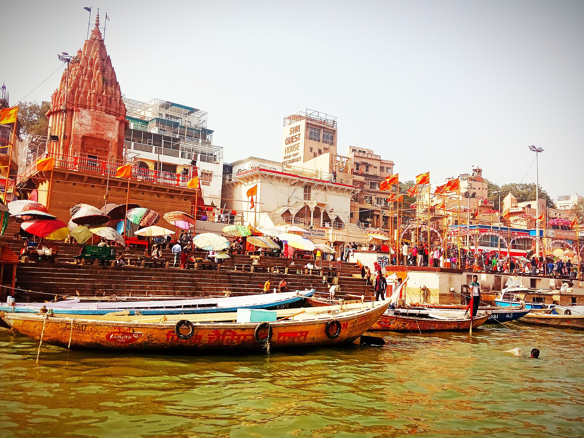
The Ganga is not merely useful. It is treated as a goddess, and bathing in it is held to cleanse accumulated wrongdoing, which is why the ghats of Varanasi, the flight of steps down to the water where cremations burn continuously at Manikarnika, function as one of the most important religious sites on earth. The Kumbh Mela, held in rotation at Prayagraj, Haridwar, Ujjain and Nashik, draws tens of millions of pilgrims to river confluences over a few weeks and has been inscribed by UNESCO on its list of intangible cultural heritage. The confluence at Prayagraj, where the Yamuna joins the Ganga and where the Sarasvati is believed to join invisibly, is called the Triveni Sangam.
The same river is badly polluted. Untreated municipal sewage is the largest contributor by volume, with industrial effluent, notably chromium from the tanneries of Kanpur, adding the most toxic component. Flow is reduced by abstraction for irrigation and by barrages, so the river's capacity to dilute what enters it has fallen just as the load has risen. The Ganga Action Plan launched in 1986 spent heavily on treatment plants with disappointing results, largely because installed capacity was not matched by the electricity, maintenance and sewer connections needed to use it. The Namami Gange programme launched in 2014 under a National Mission for Clean Ganga is a larger and better-funded successor, and stretches of the river have measurably improved, but the overall problem is not solved. In March 2017 the Uttarakhand High Court declared the Ganga and Yamuna to be living legal entities with the rights of persons; the Supreme Court stayed that order a few months later, and the question of whether rights of nature can be made to work in Indian law is unresolved.
Two longer-term pressures loom over the whole system. Groundwater in the north western plain, pumped hard for rice and wheat since the Green Revolution, is being depleted faster than it recharges, a decline visible from satellite gravity measurements, and the Himalayan glaciers that regulate dry-season flow are retreating. The Ganges river dolphin, a nearly blind freshwater species declared India's national aquatic animal in 2009, survives in scattered stretches and is a fair indicator of whether any of this is being fixed.
References
- National Mission for Clean Ganga, Government of IndiaNamami Gange Programme
- UNESCOKumbh Mela
- Encyclopaedia BritannicaGanges River
- World BankIndus Waters Treaty
- UNESCO World Heritage CentreThe Sundarbans
This is a reference article, written from the sources above. It is background, not news reporting.