

The Himalayas: A Living Boundary
Reference library · 1072 words
_in_2023-IMG-3485.jpg)
The Himalaya is not a fixed wall along the top of the subcontinent. It is a slow motion collision, still in progress, between two pieces of the earth crust that began converging tens of millions of years ago and have not stopped. The Indian plate, having broken from the ancient southern landmass of Gondwana and travelled north across the Tethys Ocean, met Eurasia roughly fifty million years ago. Because both plates carry continental crust of similar low density, neither slid cleanly beneath the other. Instead the margin crumpled, stacked and thickened. The Indian plate continues to push northward at a rate of a few centimetres a year, and the mountains continue to rise, even as erosion by ice, rivers and landslides strips material off the top almost as fast.
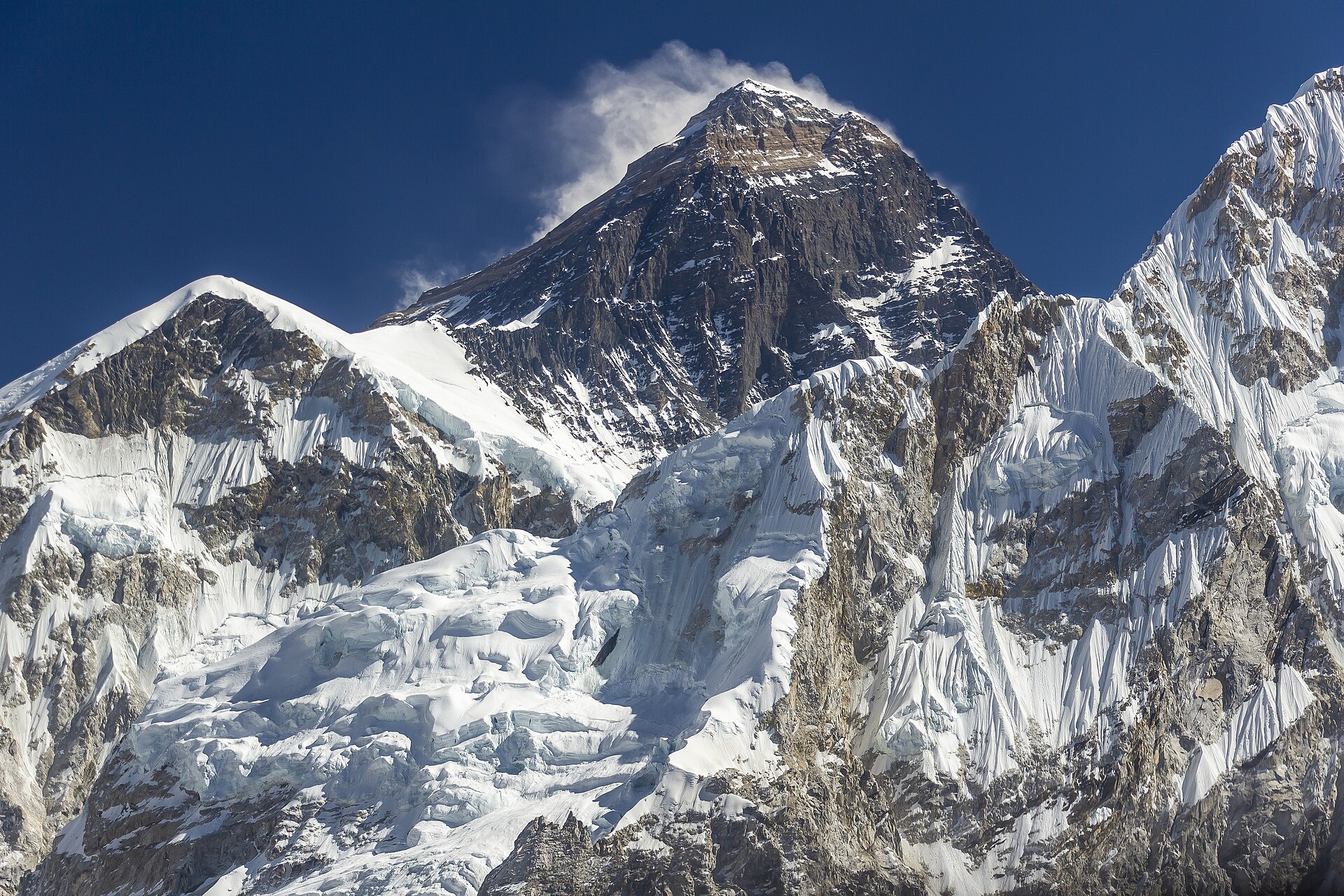
The result is an arc some 2,400 kilometres long, running from the Indus gorge in the west to the Brahmaputra bend in the east, across Pakistan, India, Nepal, China, Bhutan and Bangladesh borders. It is conventionally read as three roughly parallel belts. The Siwaliks or Outer Himalaya are low, young, poorly consolidated foothills built from sediment eroded off the range itself. Behind them the Lesser Himalaya rise to two or three thousand metres and contain the hill towns, the tea districts and most of the population. Behind those stands the Greater Himalaya, the crystalline spine carrying the highest peaks. The belts are separated by major thrust faults, the Main Boundary Thrust and the Main Central Thrust among them, along which slabs of rock have been shoved southward over younger material.
A range that shakes
Because convergence is continuous and the faults are locked for long periods before slipping, the Himalayan front is one of the most seismically dangerous places on earth. The record is unambiguous: the Bihar Nepal earthquake of 1934, which devastated Kathmandu and north Bihar; the Kangra earthquake of 1905; the Kashmir earthquake of October 2005, centred near Muzaffarabad, which killed tens of thousands and destroyed schools and hospitals across Pakistan administered Kashmir; and the Gorkha earthquake of 25 April 2015 in Nepal, which killed close to nine thousand people, flattened heritage structures in the Kathmandu valley and triggered a deadly avalanche on Everest.
Seismologists have identified stretches of the front where large strain has accumulated without a major release for centuries, and there is broad agreement that further great earthquakes are inevitable, although nobody can forecast when. The exposure has grown enormously: hill towns built on unstable slopes, unreinforced concrete construction, roads cut into fragile Siwalik rock, and hydropower reservoirs in narrow valleys. The subsidence that cracked hundreds of buildings in Joshimath, Uttarakhand, in January 2023 was not an earthquake at all, but it illustrated the same underlying problem of heavy construction on unconsolidated glacial and landslide debris.
Water, weather and the Third Pole
The range governs the climate of the whole subcontinent. It blocks cold continental air from Central Asia in winter, which is a large part of why northern India is warmer than latitudes elsewhere would suggest, and it forces the summer monsoon to rise and dump its moisture on the southern slopes. The Meghalaya hills at Cherrapunji and Mawsynram, standing in the path of moist air funnelled up from the Bay of Bengal, receive among the highest rainfall totals recorded anywhere.
The mountains also store water. The Himalaya and the adjoining Karakoram and Tibetan plateau hold more ice than anywhere outside the polar regions, which is why the region is often called the Third Pole. From it flow the Indus, the Ganga and the Brahmaputra, along with the Sutlej and the Kosi, together supplying water to a population running into the hundreds of millions. Several of these rivers are older than the mountains they cross: the Indus and the Brahmaputra rise on the Tibetan side and cut through the range in enormous gorges, having maintained their courses as the land rose beneath them, a pattern geologists call antecedent drainage.
Glacier retreat is real and well measured for many glaciers, including the Gangotri glacier at the source of the Bhagirathi. The details, however, have been contested since the Intergovernmental Panel on Climate Change was forced in 2010 to withdraw a statement in its 2007 report suggesting Himalayan glaciers could disappear by 2035, a claim not supported by the underlying science. Complicating matters further, glaciers in the Karakoram have behaved anomalously, with several stable or advancing, a phenomenon researchers call the Karakoram anomaly and do not fully understand. What is clear is that meltwater matters most in the dry season and in the western basins, that glacial lakes formed behind unstable moraines pose a flood risk, and that the disaster in the Rishiganga and Dhauliganga valleys of Chamoli district in February 2021, caused by a rock and ice avalanche, showed how quickly a high mountain failure can destroy infrastructure far downstream.
A political frontier
The Himalaya became a contested boundary at almost the moment it became an international one. British era demarcations, including the McMahon Line agreed at the Simla Convention of 1914 and never accepted by China, left the eastern alignment disputed, while in the west the Aksai Chin plateau was claimed by India and occupied by China, which built a road across it in the 1950s. The border war of 1962 settled nothing legally and left a Line of Actual Control that both armies patrol and periodically clash along, most seriously in the Galwan valley in June 2020. To the west, the Line of Control divides Kashmir between India and Pakistan, and the Siachen glacier, occupied by Indian forces in April 1984, has been garrisoned ever since at altitudes where the weather kills more soldiers than combat.
Alongside all of this the range remains a religious geography. Mount Kailash in Tibet is sacred to Hindus, Buddhists, Jains and the Bon tradition and is not climbed. Pilgrims walk to Amarnath in Kashmir, to Kedarnath and Badrinath among the Char Dham shrines of Uttarakhand, and to Hemkund Sahib for Sikhs. Those pilgrimages now move hundreds of thousands of people a year on roads carved into slopes that fail regularly, as the Kedarnath floods of June 2013 demonstrated at terrible cost. The Himalaya is simultaneously a biodiversity hotspot, a water tower, a fault line, a militarised border and a place of worship, and every one of those roles is currently under strain from the same thing: too many people and too much concrete on ground that has never stopped moving.
References
- United States Geological SurveyHimalaya tectonics and earthquake hazard
- International Centre for Integrated Mountain DevelopmentHindu Kush Himalaya assessment
- Encyclopaedia BritannicaHimalayas mountain system
- Geological Survey of IndiaGeology of the Himalaya
- India Meteorological DepartmentMonsoon and climate of India
This is a reference article, written from the sources above. It is background, not news reporting.